Station Location
Risk Demand Analysis
Current Demographics
Our team will review current Municipal and District data, resource information, and mapping. We will consult with staff to obtain available copies of supporting documents including but not limited to:
- Required site size
- Response data
- ISO criteria and existing rating
- Future land use and zoning
- Existing and future development in the Fire Response Area (FRA)
- Existing and future population conditions within the FRA
- All other existing digital (CAD and GIS) and hard copy data layers for use in the study, including but not limited to parcel mapping, roadway centerline data, streams/lakes, utility data, extraterritorial boundaries, aerial photography, building locations, call locations not all ready in our data set and any other data sets necessary.
GIS MAPPING
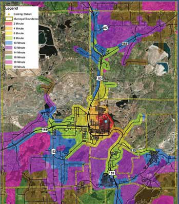
Acceptable response times within the fire station’s geographic responsibility zone is the most important factor in the final site decision. Our methodology looks at response times and required response times based on population densities, population projections and national standards. This is true for both EMS and fire units.
Using GIS our Team will complete the following:
The land use/zoning of the surrounding townships and determine potential growth areas utilizing the collected data layers.
- Calculate response times for the Fire Response Area for any new road/growth areas added to the existing scenario to determine deficiencies in the response time zones. This will assist in determining whether new or relocated facilities are needed.
- Review the existing County data layers, update the roadways with speed limits based on type of street and model the existing response times for the department.
- Assess future growth in fire response area for 5-10-20 years using the existing comprehensive plans from the Municipal data.
- Assess location of existing facility site, travel routes, response time, etc. This assessment will include the overlay of the best locations for response times, with the municipal owned properties, to better locate already owned properties to facilitate the use of existing municipal land for any new location.
Response Time and Location GIS Mapping Deliverables
Our Team will utilize the County road centerline layer with all of its attributes (speed limits, etc.), along with the location data for the calls from the department’s files, to create a transportation model for use in ArcInfo 9.2. We will use the ArcInfo network tools then to model the following scenarios for response times:
Scenario 1: Existing response times in intervals of minutes (2-, 3-,4-, 5-, 6-, 7- and 8-minute response capabilities and distance). Analyzing the existing scenario, our GIS staff will analyze the roadway network to determine locations of roadway segments that may assist in improving the response times.
Scenario 2: Analyzing the existing scenario and the deficient areas, our Team will run a scenario keeping the existing station and/or relocating it as needed to more effectively cover the response area.
Scenario 3: Our Team will analyze the entire response area and locate a station as though no station currently exists.
Other Factors
Fire station siting is more than just looking at response times. Five Bugles Design has developed a site assessment matrix that comprehensively measures multiple criteria of a site for an emergency services facility. Included in this evaluation are not only typical architectural considerations such as utilities, water/runoff retention, grade issues, and soil conditions but also emergency service components such as travel times, response routes, limitations from railroad tracks, bridges, street width, congested traffic areas, apparatus topographic limitations, apparatus turning radius, and drive through bay consideration. Response times for volunteers to the station is also a major consideration.

